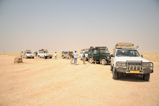
We all met at the road out of town at 10 o’clock in the morning. This was the first time I met Tom, who is a lovely gentleman. As you can see below, it was a gray, overcast and somewhat cold in Henties Bay but we were in excellent spirits and headed for the sun! Here’s a picture of our motely group…ages 54 to 80!
 |
| Ready to leave cold Henties Bay! |
We travelled on the C 35 towards Uis, below is a picture of our first stop. The topography is still quite flat although the rolling desert hills are starting to build towards the Brandberg mountain. Unfortunately this time of year there is a lot of haze (dust). This is winter in Namibia and the summer rains, which start in December will clear the air. The grass now is yellow but with the first rains new green shoots will sprout and the landscape will look much more green.
 |
| The entire convoy at first stop |
Near the Brandberg there are many local shops beside the road selling rocks and crystals. There are quartz and amethyst crystals and many different varieties of stones which come from the Brandberg.
 |
| Brandberg in the distance through the haze |
 |
| "local shop" |
The first road sign warning of elephants was spotted before the Ugab river, where we stopped for lunch. We didn’t see any other elephant signs, other than one pile of dung on the road so we were quite comfortable having lunch in the mostly dry Ugab river. Namibia received a lot of rain last summer and many of the normally dry rivers still have spots containing water. This is a wonderful thing for a country that is mostly arid.
 |
| Sign warning of desert elephants that travel the Ugab |
 |
| Lunch spot along the Ugab |
After lunch we started passing roadside shops run by the Herero people, below is a picture of an Herero woman. The clothing style you see was adopted from the early Victorian woman missionaries. The cloth they use is very colorful and they are always a pleasure to see. I think their head dress looks like cow horns…but who knows why they developed that style?
 |
| Herero woman at local shop |
Namibia set aside land for local tribes back in the 1960’s: the Herero live in Herero land, the Damara in Damaraland, the Ovambo in Ovamboland, etc. Kaokoland is mainly comprised of the Herero tribe, which is a big tribe comprised of many smaller tribes. The Himba are Herero, that is they speak the same language…but other than that…they appear to have little in common. After traveling a few hours we reached Kamanjab…a small town on the edge of the frontier. Just beyond Kamanjab, Bertie Botha’s son’s farm starts. Bertie and Dawn lived on and ran this farm for 12 or so years before turning it over to their son. It is 8,000 hectar…which I think is about 16,000 acres…and there are about 800 head of cattle here. There are also 55 or so giraffe…minus a couple…and plus a couple of new babies. Here are some photos of giraffe we spotted on the way to the farm.
 |
| Friend of Bertie |
 |
| The farmhouse |
 |
| Sunset at Bertie's |
After arriving at Bertie’s farm, we unloaded for the evening and prepared to braai! What a lovely and peaceful place it was…thanks to Bertie and Dawn for our first evening’s accommodation.
 |
Relaxing before the braai!
|


No comments:
Post a Comment